
Table of Contents
There's a version of the US that is best experienced from a train window. Different from the one that’s seen when you’re cramped in coach on an airplane or stuck in rush hour on the interstate. One where rolling sunflower fields turn into red rock canyons blazing beneath the midday sun, turn into glaciated peaks rising from the horizon, all within the span of a few days. And to think you didn’t even need to take out Google Maps once to navigate all of that.
Train travel in the US has been making a comeback in recent years, with Amtrak seeing all-time-high ridership in 2025. This guide covers 17 of the top train routes in the US, from Amtrak's great long-distance trains to heritage steam railways that have been running the same narrow-gauge tracks since the mining era.
We've organized them by region, but many of these journeys cross so much ground that they could easily belong to two or three sections. We've placed each route where you’ll find most of its defining highlights, but the joys of each journey often extend far beyond.
One more thing before you start planning: Many of these routes work best as one-way journeys rather than out-and-back trips. If that's the case, look at booking an open-jaw flight—flying into one endpoint and out of the other. Open-jaw tickets often cost the same as a standard roundtrip, and sometimes less if you're flexible with dates and airlines.

Pacific Coast and the West
Coast Starlight: Seattle ↔ Los Angeles
- Traverses: Washington, Oregon, Northern California, Central Coast, Southern California
- Distance: 1,377 miles
- Journey time: 35 hours
- Best time to go: Year-round; spring and fall for mild weather and clearer skies
- Highlights: Puget Sound, Cascade Range, Mount Shasta, Sacramento Valley, Santa Barbara coastline, Pacific Ocean views
- Airports: Seattle-Tacoma International Airport (SEA), Los Angeles International Airport (LAX)
Despite what the name suggests, the Coast Starlight doesn't hug the Pacific for its entire length. But when it does, around the Santa Barbara portion, the payoff is worth the wait. This is the quintessential West Coast train, passing through an almost comical range of landscapes along the way.
Heading south from Seattle, you'll trace Puget Sound through the forests of Washington before crossing into Oregon and following the Columbia River. The drama builds through Northern California, where Mount Shasta rises to over 14,000 feet, and the landscape opens into the Sacramento Valley. By the time the train sweeps south through wine country and into Santa Barbara, you're riding right along the Pacific. Book a roomette for the overnight leg, and use the Sightseer Lounge (a glass-ceilinged observation car) to catch the scenery unrestricted.
Average Going deal price to the nearest major airports:
- Seattle: $155 roundtrip
- Los Angeles: $186 roundtrip
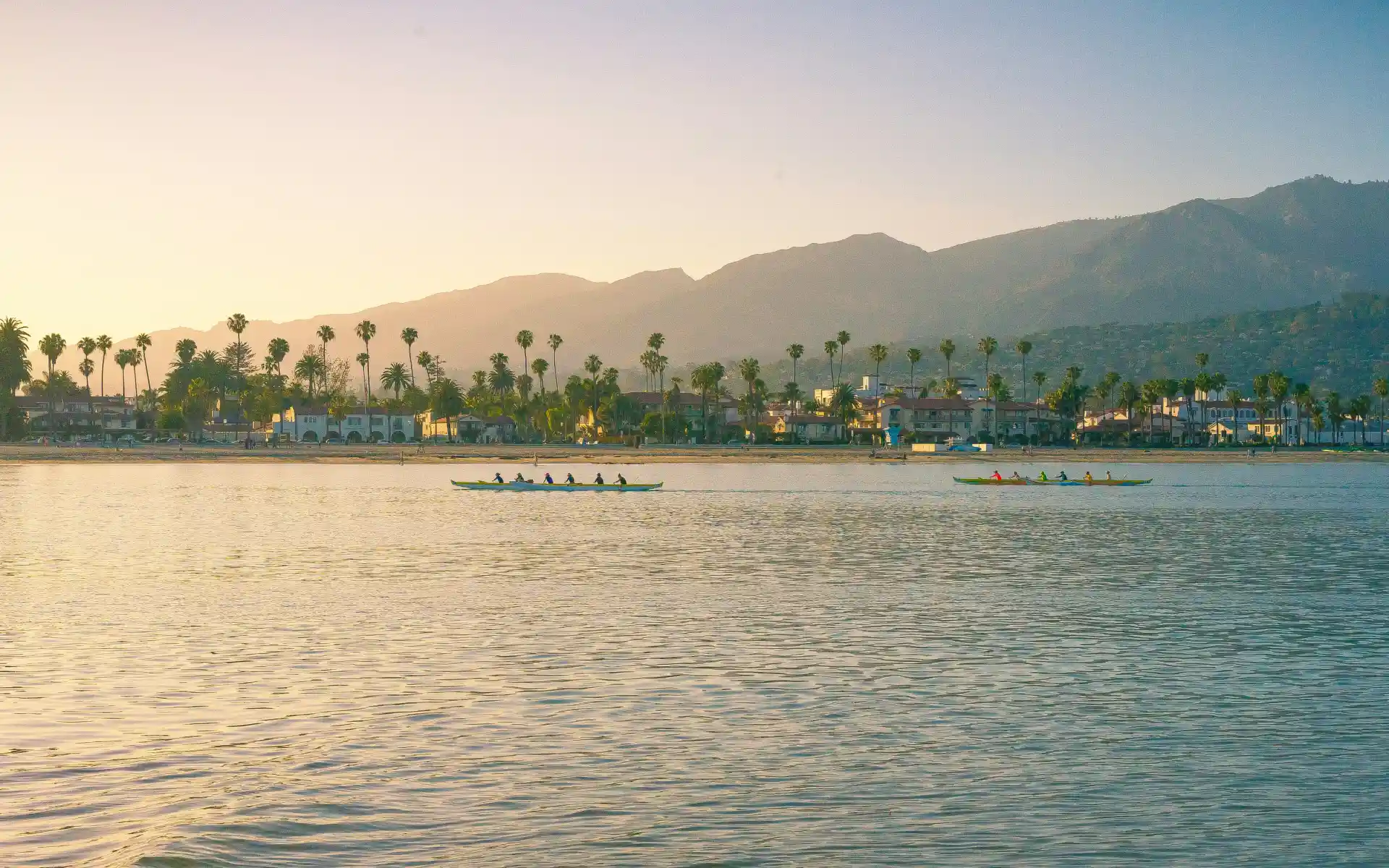
Pacific Surfliner: San Luis Obispo ↔ San Diego

- Traverses: California Central Coast, Los Angeles Basin, Orange County, San Diego
- Distance: 351 miles
- Journey time: 9 hours (full route); 3 hours Los Angeles to San Diego
- Best time to go: Year-round
- Highlights: Santa Barbara, Ventura coastline, Los Angeles Union Station, Anaheim, Solana Beach, San Diego
- Airports: Santa Barbara Airport (SBA), Los Angeles International Airport (LAX), San Diego International Airport (SAN)
The Pacific Surfliner runs multiple times daily along the Southern California coast. For stretches between Ventura and the LA basin, and again south through Oceanside and Solana Beach, the train runs close enough to the water that you can practically count the surfers. It's the most relaxed way to cover the southern California coast, and because it runs so frequently, you can hop on for a short segment (like Los Angeles to Santa Barbara, or Anaheim to San Diego) without committing to the full route.
The full San Luis Obispo to San Diego run is worth doing at least once, though. SLO is charming with great wine-country access, Santa Barbara is perfect for a pit stop, and LA’s Union Station is a historic gem and beautiful to boot. The Pacific Surfliner is strictly a daytime train, so you won’t have overnight accommodations.
Average Going deal price to the nearest major airports:
- Los Angeles: $186 roundtrip
- San Diego: $174 roundtrip
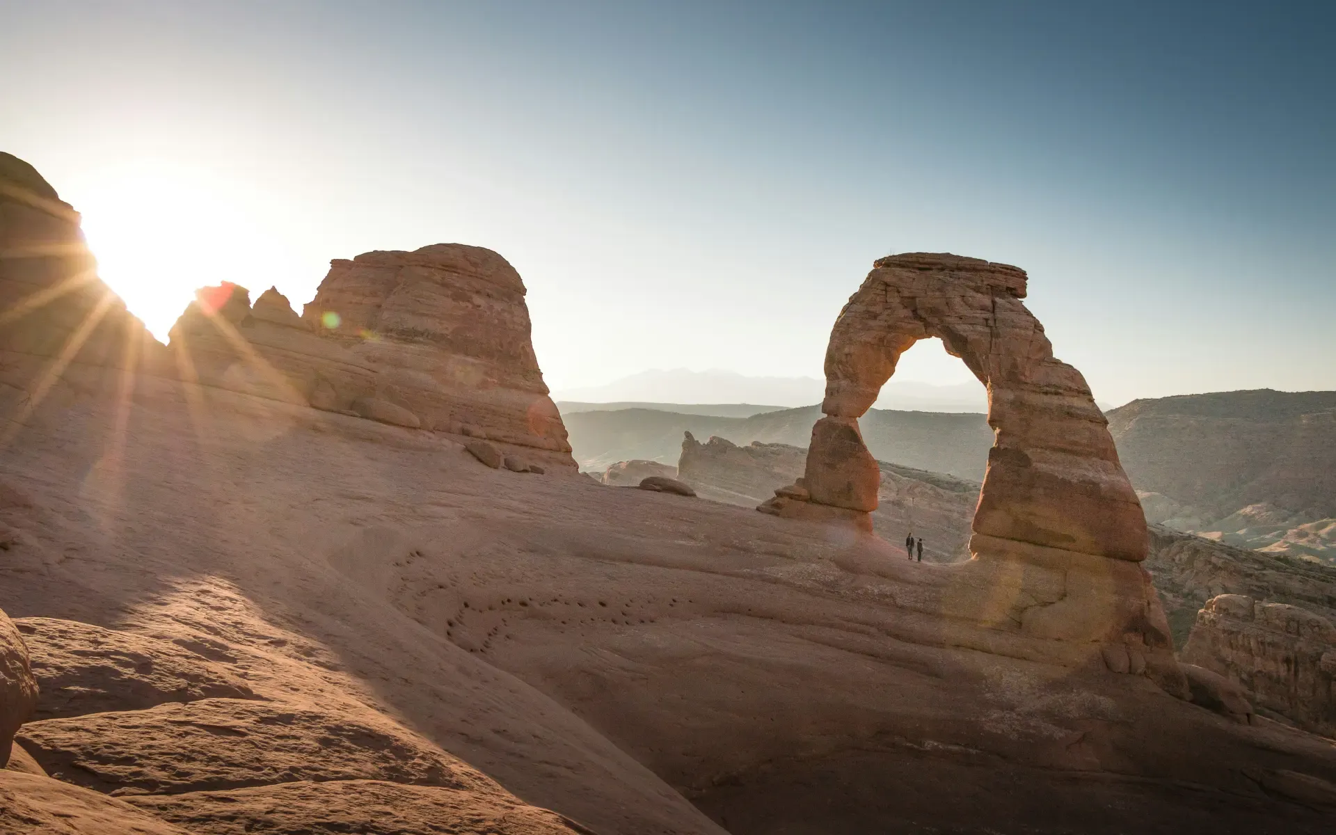
Canyon Spirit: Denver ↔ Moab or Salt Lake City
- Traverses: Colorado Rockies, Colorado River canyon country, Utah's red rock desert, Great Basin
- Distance: 369 miles (Denver–Moab portion), 602 miles (Denver–Salt Lake City route)
- Journey time: 2 days (Denver to Moab), 3 days (Denver to Salt Lake City); daylight travel only with overnight hotel stops
- Best time to go: April–October
- Highlights: Colorado River canyon, Glenwood Canyon, Ruby Canyon (accessible only by rail), red rock formations near Moab, Utah high desert
- Airports: Denver International Airport (DEN), Salt Lake City International Airport (SLC)
Canyon Spirit, formerly known as Rocky Mountaineer before rebranding for the 2026 season, is an elevated rail journey with regionally inspired meals and a strict daylight-only travel policy, so you’ll never miss the view because you're asleep. The train stops overnight in Glenwood Springs and Moab, so you can explore both towns before continuing.
On day one, the train follows the Colorado River through Glenwood Canyon, a narrow gorge that took 12 years to build the road through it. Day two winds into Ruby Canyon and the red rock landscape of eastern Utah, an area so remote it's accessible only by train or river. For the three-day Salt Lake City extension, day three crosses Utah's high desert toward the Wasatch Front. If Moab's Arches and Canyonlands parks are on your list, this is a stylish way to make your entrance.
Average Going deal price to the nearest major airports:
- Denver: $174 roundtrip
- Salt Lake City: $189 roundtrip
Rockies and the Southwest
California Zephyr: Chicago ↔ Emeryville, CA
- Traverses: Illinois, Iowa, Nebraska, Colorado, Utah, Nevada, California
- Distance: 2,438 miles
- Journey time: ~52 hours
- Best time to go: May–October for clearest mountain views; westbound recommended for best daylight through the Rockies
- Highlights: Denver Union Station, Moffat Tunnel (6.2 miles under the Continental Divide), Glenwood Canyon, Colorado River, Book Cliffs, Bonneville Salt Flats, Sierra Nevada, Donner Lake
- Airports: Chicago O'Hare International Airport (ORD), San Francisco International Airport (SFO) or Oakland International Airport (OAK) via Amtrak bus from Emeryville
Amtrak's longest daily route is also widely regarded as its most beautiful. After 52 hours crossing seven states, you’ll find it difficult to disagree. The California Zephyr connects Chicago's Union Station to the San Francisco Bay Area, but the termini are just the beginning. In between, the Great Plains give way to the Rockies before the train climbs through Glenwood Canyon, following the Colorado River for 12 miles through walls of sheer rock, and crests the Continental Divide via the Moffat Tunnel before descending into the desert canyons of Utah.
Then the landscape shifts again. The Utah red rock and the Bonneville Salt Flats on the Utah-Nevada state line feel lunar before you head for California’s Sierra Nevadas. There’s a postcard-perfect glimpse of Donner Lake, then the train descends into Sacramento and rolls toward the Bay. Book a sleeper room if you can.
Average Going deal price to the nearest major airports:
- Chicago: $193 roundtrip
- San Francisco: $223 roundtrip
Southwest Chief: Chicago ↔ Los Angeles
- Traverses: Illinois, Missouri, Kansas, Colorado, New Mexico, Arizona, California
- Distance: 2,265 miles
- Journey time: 40+ hours
- Best time to go: Year-round; westbound for the best desert sunset experience
- Highlights: Kansas plains, Raton Pass (Colorado/New Mexico border), Santa Fe region, New Mexico high desert, Albuquerque, Flagstaff (gateway to Grand Canyon), Mojave Desert
- Airports: Chicago O'Hare International Airport (ORD), Los Angeles International Airport (LAX)
The Southwest Chief follows stretches of the historic Route 66 corridor across the southern half of the country. The train departs Chicago and puts the most dramatic scenery in daylight. The Raton Pass crossing between Colorado and New Mexico is a highlight, climbing through the Sangre de Cristo foothills before descending into the high desert country around Lamy (the stop for Santa Fe). From there you'll drift through the New Mexico desert, Albuquerque, and the Arizona Painted Desert before you reach Flagstaff, a natural jumping-off point for the Grand Canyon, and continue through the Mojave into Los Angeles.
If you only take one of the great transcontinental Amtrak routes, the Southwest Chief's southern route is a prime candidate, with dramatic, wide-open landscapes, the sunsets over the New Mexico desert, and a two-night journey that gives you enough time to settle into a rhythm while also always giving you something new and beautiful to look at.
Average Going deal price to the nearest major airports:
- Chicago: $193 roundtrip
- Los Angeles: $186 roundtrip
Sunset Limited: New Orleans ↔ Los Angeles

- Traverses: Louisiana, Texas (Houston, San Antonio, El Paso), New Mexico, Arizona, California
- Distance: 1,995 miles
- Journey time: 48 hours
- Best time to go: October–April (Southwest summer temperatures can get extreme)
- Highlights: Bayou country outside New Orleans, Houston, San Antonio, Big Bend country (deboard at Alpine), El Paso/Ciudad Juárez border, Tucson and Saguaro National Park, Sonoran Desert, Palm Springs
- Airports: Louis Armstrong New Orleans International Airport (MSY), Los Angeles International Airport (LAX)
America's southernmost train route, the Sunset Limited, runs three times a week in each direction. It traces the Gulf Coast out of New Orleans, cuts through Texas (Houston, San Antonio, then a long and lonely crossing of west Texas), crosses the border region near El Paso, and carves through southern New Mexico and Arizona before arriving in Los Angeles via Palm Springs. Given the limited tri-weekly schedule, plan early to ensure you get a spot.
Average Going deal price to the nearest major airports:
- New Orleans: $175 roundtrip
- Los Angeles: $186 roundtrip
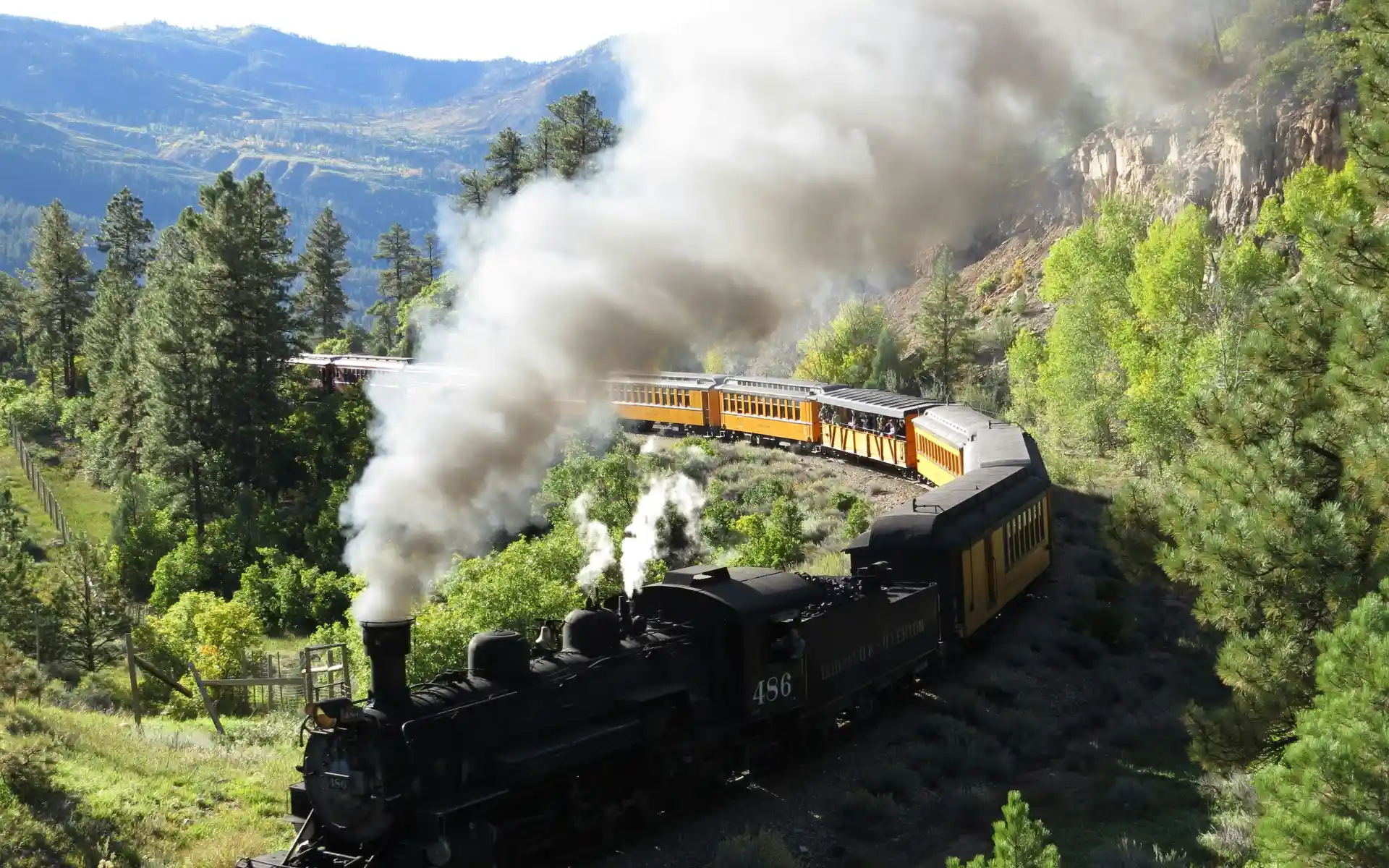
Durango & Silverton Narrow Gauge Railroad: Durango ↔ Silverton, Colorado
- Traverses: Colorado (San Juan Mountains)
- Distance: 45 miles each way
- Journey time: 9 hours roundtrip, including a 2-hour stop in Silverton
- Best time to go: May–October for full service; limited winter service
- Highlights: Animas River Canyon, San Juan National Forest, Silverton (historic mining town), elevation gain of nearly 3,000 feet
- Airports: Durango–La Plata County Airport (DRO), Denver (DEN) is the nearest major airport
Coal-fired, steam-powered, narrow gauge, and running the same tracks since 1882. The Durango & Silverton is definitely not trying to be a modern train experience, and that's the point. The locomotives, lovingly restored 1920s-era steam engines, haul open-air gondola cars and enclosed coaches through Animas River Canyon at a top speed of about 18 miles per hour, slow enough to savor everything.
The route climbs nearly 3,000 feet in 45 miles, clinging to narrow ledges above the Animas River with sheer canyon walls on one side and big drops on the other. There's no road access to most of what you'll see, as this is backcountry accessible only by train or on foot. The two-hour layover in Silverton, a spectacularly intact Victorian mining town at 9,300 feet, is a bonus. Stay overnight in Silverton, and return the next day if you can.
Average Going deal price to the nearest major airports:
- Denver: $174 roundtrip
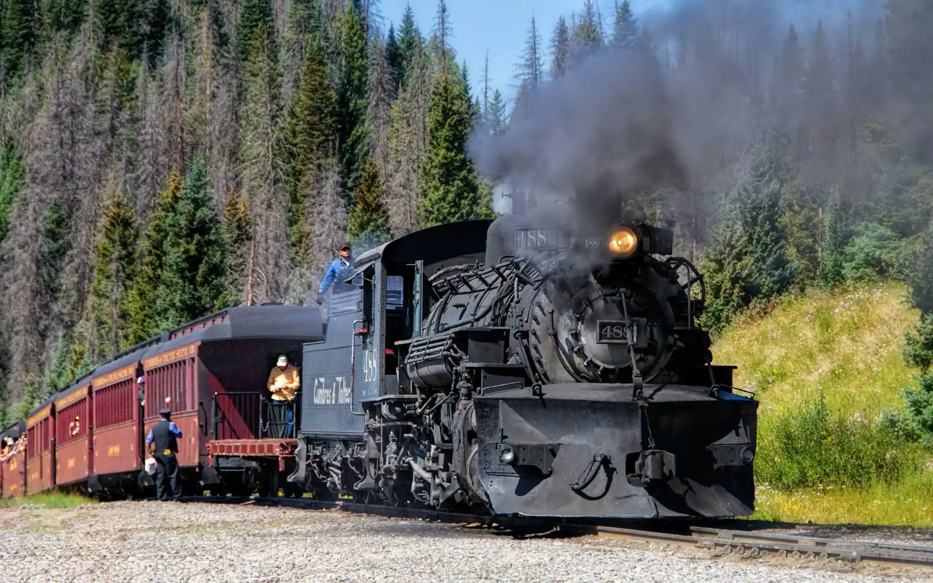
Cumbres & Toltec Scenic Railroad: Chama, NM ↔ Antonito, CO
- Traverses: Northern New Mexico, Southern Colorado
- Distance: 64 miles
- Journey time: 2–8 hours
- Best time to go: Late May–mid-October
- Highlights: Cumbres Pass (10,015 feet, the highest point on any US steam railroad), Toltec Gorge, aspen groves, high alpine meadows
- Airports: Albuquerque International Sunport (ABQ) is about 3 hours from Chama, Pueblo Memorial Airport (PUB) is roughly 2 hours from Antonito
The Cumbres & Toltec and the Durango & Silverton share common ancestors—both are remnants of the old Denver & Rio Grande Western narrow-gauge network—but they feel distinct. While the Durango & Silverton runs through canyon lands, the Cumbres & Toltec crosses high alpine country characterized by meadows, aspen forests, and the sweeping wide-open landscape of the southern Colorado Rockies. Cumbres Pass at 10,015 feet is the highest point reached by any steam railroad in the US.
Fall is the best time to experience this route, when the aspens turn the hillsides gold and the steam against crisp mountain air makes for extraordinary photos.
Average Going deal price to the nearest major airport:
- Albuquerque: $199 roundtrip
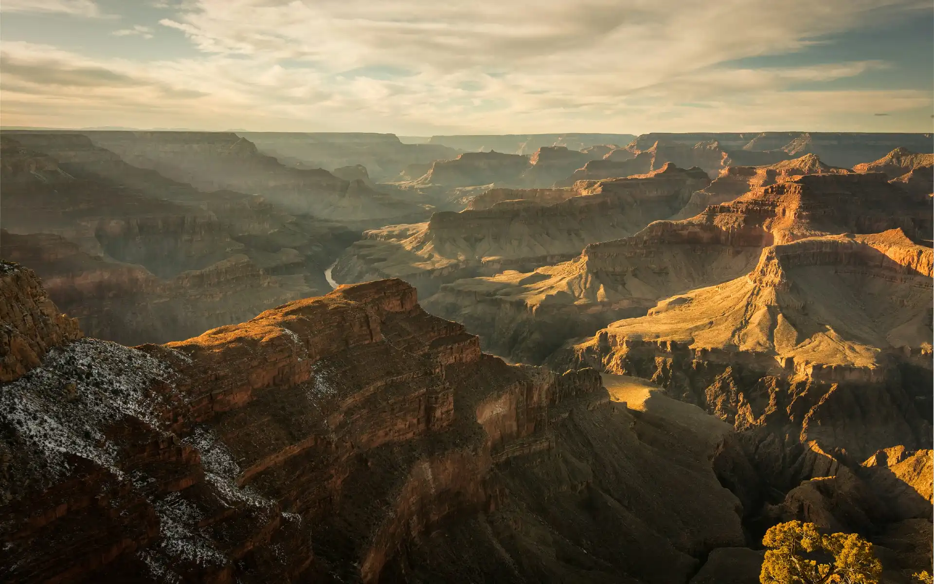
Grand Canyon Railway: Williams ↔ Grand Canyon Village, Arizona
- Traverses: Northern Arizona
- Distance: 65 miles each way
- Journey time: 2 hours 15 minutes each way
- Best time to go: Year-round; spring and fall for mild South Rim weather
- Highlights: Ponderosa pine forests, high desert prairie, Grand Canyon South Rim
- Airports: Phoenix Sky Harbor International Airport (PHX) is about 2.5 hours from Williams; Flagstaff Pulliam Airport (FLG) is 30 miles east
If you’re going for practicality, skip the parking nightmare at the South Rim, and ride the Grand Canyon Railway vintage train through the high desert instead, stepping off 200 feet from the canyon rim. Practicality aside, the Grand Canyon Railway is worth the journey anyway. The train, a restored diesel locomotive hauling vintage cars, departs daily from the Route 66 town of Williams, and the journey features roaming musicians, cowboy characters, and the occasional mock train robbery that will either delight or slightly embarrass you depending on your tolerance for theatrical Americana.
The scenery shifts from ponderosa pine forest to open grassland and high-desert prairie as you climb toward the South Rim, with the San Francisco Peaks visible to the east. You get just over three hours at the Grand Canyon before boarding for the return trip, enough for a solid walk along the Rim Trail and a look at the historic El Tovar Hotel. If you can, spend a night at the rim.
Average Going deal price to the nearest major airport:
- Phoenix: $169 roundtrip

Pacific Northwest & Alaska
Empire Builder: Chicago ↔ Seattle or Portland
- Traverses: Illinois, Wisconsin, Minnesota, North Dakota, Montana, Idaho, Washington (Seattle section) or Oregon (Portland section)
- Distance: 2,206 miles (Chicago–Seattle); 2,257 miles (Chicago–Portland)
- Journey time: 46 hours
- Best time to go: Summer and early fall for Glacier National Park access; eastbound recommended for best daylight views
- Highlights: Mississippi River, Minnesota lakes, North Dakota plains, Glacier National Park (Whitefish stop), Columbia River Gorge, Puget Sound, Seattle or Portland
- Airports: Chicago O'Hare International Airport (ORD), Seattle-Tacoma International Airport (SEA), Portland International Airport (PDX)
The Empire Builder route has been carrying passengers across the northern part of the US since 1929. Originally part of the Great Northern Railway, its operations were taken over by Amtrak in 1971. The train departs Chicago and splits west of Spokane, with one section heading to Seattle and the other to Portland. What defines the Builder is the grandeur spanning its two-night crossing, beginning with the Mississippi River in Minneapolis, the wide-open North Dakota plains, then the Rockies once you hit Montana.
The crown jewel of the journey is Glacier National Park, with stops at Essex, East Glacier, and Whitefish giving passengers direct access to the park's lodges and trailheads. The Columbia River Gorge, on the final approach to Portland, is a dramatic stretch. The river carves through the Cascades, and the walls rise sheer on both sides. Book eastbound if you can: The timing puts Glacier in daylight.
Average Going deal price to the nearest major airports:
- Chicago: $193 roundtrip
- Seattle: $155 roundtrip
- Portland: $169 roundtrip
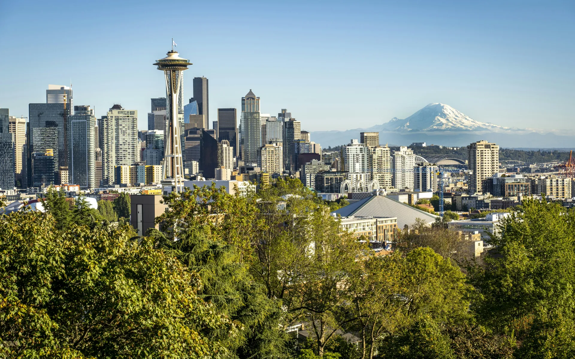
Amtrak Cascades: Eugene, OR ↔ Vancouver, BC
- Traverses: Oregon (Willamette Valley), Washington (Seattle, Puget Sound, Bellingham), British Columbia (Vancouver)
- Distance: 460 miles
- Journey time: 10.5 hours (full route); multiple daily trains on shorter segments
- Best time to go: Year-round; summer for best visibility, spring for green landscapes
- Highlights: Willamette Valley vineyards, Portland, Puget Sound, Chuckanut Bay, Bellingham, Salish Sea, Vancouver (British Columbia)
- Airports: Portland International Airport (PDX), Seattle-Tacoma International Airport (SEA), Vancouver International Airport (YVR)
Pretty epic and practical, Amtrak Cascades happens to be one of the most useful and scenically rewarding regional routes in the country. Multiple trains run daily between Eugene, Portland, and Seattle, with a single daily train continuing to Vancouver, British Columbia. As it’s a daytime route, you get to see everything: the wide Willamette Valley farmland south of Portland, the Columbia River crossing into Washington, and the stretch through Chuckanut Bay and along the Salish Sea north of Seattle, where the water and mountains basically become one.
The international run to Vancouver is an extra treat. After you clear US customs at the station, the scenery builds through Bellingham and the Fraser River delta before you arrive at Pacific Central Station in one of North America's most livable cities. You won’t regret a trip flying into Portland, taking the train to Vancouver, and flying back home.
Average Going deal price to the nearest major airports:
- Portland: $169 roundtrip
- Seattle: $155 roundtrip
- Vancouver: $265 roundtrip
White Pass & Yukon Route: Skagway, AK ↔ Fraser/Carcross (Yukon)
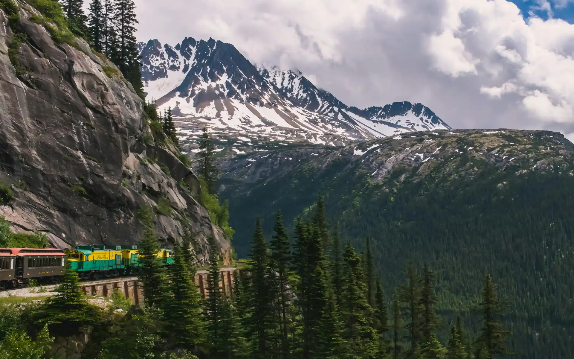
- Traverses: Alaska (Skagway), British Columbia, Yukon Territory
- Distance: 40 miles for the main White Pass Summit excursion, 67.5 miles to Carcross
- Journey time: 2.5–3 hours (White Pass Summit roundtrip); 6.5–8 hours (Carcross)
- Best time to go: Mid-May to late September (cruise season)
- Highlights: Dead Horse Gulch, White Pass Summit (2,865 feet), Skagway River gorge, glaciers, Klondike Gold Rush historical sites, Carcross Desert (world's smallest desert)
- Airports: Skagway Airport (SGY) is tiny and primarily serves small planes; most visitors arrive by Alaska Marine Highway ferry or cruise ship
Built in 1898 at the height of the Klondike Gold Rush to carry prospectors and supplies over the White Pass into the Yukon, this narrow-gauge railway is an International Historic Civil Engineering Landmark, a designation it shares with the Panama Canal, the Eiffel Tower, and the Statue of Liberty. The tracks were built into the mountain face in about two years, and the result is a route that climbs 2,865 feet in 20 miles, traversing sheer rock faces, crossing gorges on steel trestles, and passing through tunnels carved by hand.
The scenery includes glaciers, waterfalls, and the Skagway River gorge below, all moving past at the measured pace of a train that knows it has nowhere to hurry. Most visitors do the White Pass Summit roundtrip as a shore excursion from a cruise ship, but the full day trip to Carcross in the Yukon, complete with a stop at the Carcross Desert, is worth the extra hours.
Average Going deal price to nearest major airport:
- Anchorage: $338 roundtrip
Midwest & South
City of New Orleans: Chicago ↔ New Orleans

- Traverses: Illinois, western Kentucky, Tennessee, Mississippi, Louisiana
- Distance: 900+ miles
- Journey time: 19 hours
- Best time to go: Spring or fall; avoid summer heat in the Deep South
- Highlights: Chicago skyline departure, Mississippi River views, Memphis, the Mississippi Delta, Louisiana bayou country, New Orleans
- Airports: Chicago O'Hare International Airport (ORD), Louis Armstrong New Orleans International Airport (MSY)
Arlo Guthrie put this train on the map in 1971 with his song of the same name, and the song nails the feeling: The City of New Orleans is less a transportation decision and more a decision to spend 19 hours watching the American South unfold from a comfortable seat. It departs Chicago in the afternoon, crosses into the Mississippi Delta country overnight, passes, albeit briefly, through Memphis, and arrives in New Orleans the following morning, right in time for beignets at Café Du Monde.
The route is intimate compared to the great western epics. One state bleeds into the next, small towns appear and disappear in the blink of an eye, and the landscape shifts incrementally from the Illinois prairie to the bayous of Louisiana. It's a journey that rewards paying attention. The lounge car—where you’ll want to be for the evening run through Tennessee and Mississippi—is where the best conversations happen.
Average Going deal price to the nearest major airports:
- Chicago: $193 roundtrip
- New Orleans: $175 roundtrip
East Coast and the Northeast
Lake Shore Limited: Chicago ↔ New York City (or Boston)
- Traverses: Illinois, Indiana, Ohio, Pennsylvania, New York, Massachusetts (Boston section)
- Distance: 959 miles (Chicago–New York), 1,018 miles (Chicago–Boston)
- Journey time: 19 hours (Chicago–New York); 21 hours (Chicago–Boston)
- Best time to go: Year-round; fall for Hudson Valley foliage
- Highlights: Cleveland, Buffalo, Albany, Hudson River Valley, Niagara Falls (nearby), New York Penn Station
- Airports: Chicago O'Hare International Airport (ORD), New York (JFK), Newark (EWR), LaGuardia (LGA), Boston Logan International Airport (BOS)
The Lake Shore Limited traces the old New York Central "Water Level Route" from Chicago to New York, the same corridor that once carried the glamorous 20th Century Limited, widely considered the most famous passenger train in American history. Its successor is considerably less polished but no less useful, and the overnight crossing of upstate New York is beautiful. The train splits at Albany, with one section continuing to Penn Station in Manhattan and the other heading east to South Station in Boston.
The Hudson River stretch, in the final hours before New York, is the payoff: The train runs along the eastern bank of the river, with the Catskills and then the Highlands across the water. In the fall, this is one of the most spectacular pieces of rail scenery on the East Coast. Leave the curtain open, and you’ll wake up to a view.
Average Going deal price to the nearest major airports:
- Chicago: $193 roundtrip
- New York: $181 roundtrip
- Boston: $184 roundtrip
Crescent: New York City ↔ New Orleans

- Traverses: New York, New Jersey, Pennsylvania, Delaware, Maryland, Washington DC, Virginia, North Carolina, South Carolina, Georgia, Alabama, Mississippi, Louisiana
- Distance: 1,377 miles
- Journey time: ~30 hours
- Best time to go: Spring or fall; Mardi Gras timing for New Orleans arrival makes it a celebratory trip if that’s what you’re looking for, though costs will be considerably higher
- Highlights: Philadelphia, Washington DC, Charlottesville, Charlotte, Atlanta, Birmingham, the Mississippi Gulf Coast, New Orleans
- Airports: New York Penn Station (JFK, EWR, or LGA nearby), Louis Armstrong New Orleans International Airport (MSY)
The Crescent covers nearly the full length of the American East, connecting New York to New Orleans via the South's major cities and some of its quieter corners. It's a classic train with a classic American itinerary: Philadelphia and Washington in the first few hours, then south through Virginia (Charlottesville, home to Monticello, is a stop), Charlotte, Atlanta, and Birmingham, and further into the Deep South. The route runs through 13 states and touches a remarkable cross-section of American geography and history.
The approach to New Orleans, through Louisiana bayou country in the final hours, is a fitting finale. The landscape goes flat, green, and watery, the light changes, and by the time you pull into New Orleans Union Passenger Terminal, you've traveled through about 30 hours and a great deal of American history. Time a southbound trip to arrive on a Thursday or Friday, and New Orleans will take care of the rest.
Average Going deal price to the nearest major airports:
- New York: $181 roundtrip
- New Orleans: $175 roundtrip
Adirondack: New York City ↔ Montréal
- Traverses: New York (Hudson Valley, Adirondacks, Lake Champlain), Quebec (Montréal)
- Distance: 381 miles
- Journey time: 10 hours
- Best time to go: Fall for foliage; summer for lake and mountain scenery
- Highlights: Hudson River Valley, Saratoga Springs, Lake Champlain, Adirondack Mountains, Rouses Point border crossing, Montréal
- Airports: New York JFK, Newark (EWR), or LaGuardia (LGA); Montréal-Trudeau International Airport (YUL)
The Adirondack is a day train, departing New York in the morning and arriving in Montréal that evening. The Hudson River portion in the first few hours is gorgeous as the train follows the eastern bank north through the Highlands and into the valley, with the Catskills across the water. Saratoga Springs appears mid-morning (a worthy stop on its own), and then the route climbs into the Adirondacks and traces the western shore of Lake Champlain, with views across the water to Vermont.
There’s a customs stop at the US-Canada border at Rouses Point, but by the time the train pulls into Gare Centrale in Montréal, you've covered two countries and what feels like a very efficient tour of the American Northeast. Note: It’s worth checking schedule status before booking, as the Adirondack has seen periodic service interruptions due to track conditions on the Canadian side.
Average Going deal price to the nearest major airport:
- New York: $181 roundtrip
Maple Leaf: New York City ↔ Toronto
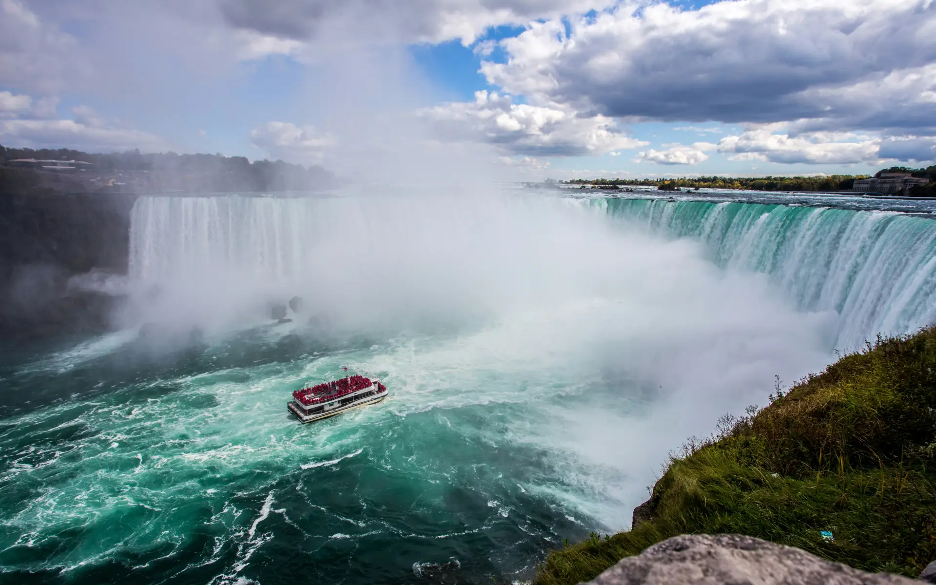
- Traverses: New York (Hudson Valley, Upstate New York, Niagara Falls), Ontario
- Distance: 544 miles
- Journey time: 12.5 hours
- Best time to go: Year-round; summer and fall for best scenery
- Highlights: Hudson River Valley, Albany, Rochester, Buffalo, Niagara Falls, Hamilton, Toronto Union Station
- Airports: New York JFK, Newark (EWR), or LaGuardia (LGA), Toronto Pearson International Airport (YYZ)
The Maple Leaf route is a standout for the sheer fact that it runs right past Niagara Falls. Note, though, that the stop there isn't long enough to see the falls properly. You'd need to deboard and spend a night. The train crosses into Canada at Niagara Falls, clears US and Canadian border formalities, and then rolls along the Canadian shore of Lake Ontario through Hamilton and into Toronto.
It's an ideal two-city trip by rail: Depart New York in the morning, arrive in Toronto in the evening, spend a few days, and fly home. Or reverse it and fly into Toronto, take the train south, and have New York waiting at the end. The Hudson Valley stretch out of Manhattan is worth staying awake for, and Toronto Union Station—one of the most impressive train terminals in North America—is a destination in itself.
Average Going deal price to the nearest major airports:
- New York: $181 roundtrip
- Toronto: $277 roundtrip
Last updated May 22, 2026
Articles you might like
View All